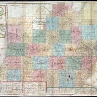
An improved edition of a map of the surveyed parts of the Territory of Michigan
Dublin Core
Title
An improved edition of a map of the surveyed parts of the Territory of Michigan
Subject
Treaty of 1836
Description
Covers southern Michigan.
Insets: Map of the Straits of Michillimackinac. -- Map of Pte. Ste. Ignace. -- Map of the most important parts of the lead mine district near the Mississippi River. -- Map of the private claims at Green Bay -- Map of Michillimackinac.
Insets: Map of the Straits of Michillimackinac. -- Map of Pte. Ste. Ignace. -- Map of the most important parts of the lead mine district near the Mississippi River. -- Map of the private claims at Green Bay -- Map of Michillimackinac.
Creator
John Farmer
Source
Michigan State University Library
Publisher
New York, N.Y. : J.H. Colton and Co., 1836.
Date
1836
Contributor
Kathleen Weesies, Archivist
Rights
Public Domain
Type
map
Still Image Item Type Metadata
Original Format
map
Collection
Citation
John Farmer, “An improved edition of a map of the surveyed parts of the Territory of Michigan,” Agroecology of Western Michigan, accessed September 19, 2024, https://ottojays.reclaim.hosting/cms/items/show/268.

